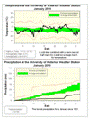
The driest January in 30 years while temperatures were about average
A very cold start to the month was balanced by a warm second half (except for the last few days) to make for an overall average month for temperature. During that second half we had a stretch of 14 warmer than average days.
The daily highs came in at 0.2 degrees below average and the daily low temperatures were 1.3 degrees above average. So overall it was 0.5 degrees above average which is still within the average range.
But the big story for January was the lack of precipitation both solid and liquid. The total precipitation was only 27.9 mm, making it the driest January since 1981 and tied for the fourth driest since records began in the area in 1914.
As far as snow, we only saw 17.5 cm. This is the least snowiest January since 1983, the seventh lowest total January snowfall in history, and less than half the average of 44 cm.
It is understandable that people have been commenting on the lack of shovelling they have had to do this winter, as we have only had 47 cm so far this snowfall season compared to the average of 97 cm. It is also quite a contrast to last year when we had around 200 cm at this point.
Summary for January 2010:
Maximum Temperature 5.2°C
Minimum Temperature -21.5°C
Average Daily High Temperature -3.3°C (Long term average -3.1°C)
Average Daily Low Temperature -9.8°C (Long term average -11.1°C)
Total Precipitation 27.9 mm (Long term average 64.4 mm)
(Long term averages based on 1971-2000 data for the Waterloo Wellington Airport)
Sign up to get the monthly weather station summary by e-mail


2 comments:
why not calculate an average temperature based on all the measured temperatures (every 15 minutes?) for the month?
That would be the best way to do it, however the only 15 minute source that I know of is the weather station.
Unfortunately we have only been around for about 12 years now and it is generally accepted that you need 30 years of data to make proper meteorological averages.
But I promise that in March of 2028 we will start to use the 30 averages from the UW weather station.
Post a Comment