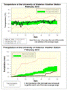
Apart from a couple of colder nights in the first week of the month, the temperatures in February stayed very much within the average range. The daily high temperatures were never more than 5 degrees away from the average while the lows only occasionally got out of that range, mostly on the warm side. But even these warm nights couldn’t get the temperature out of the average range overall.
Another dry month with only 30.9 mm compared to the average of 51.3 mm. Almost half of that came during the 22nd when 13.2 mm of precipitation came down. That storm prevented it from being a historically dry month, but it was still below average.
The total snowfall of around 30 cm was pretty much exactly the long term average, but as most of it came during one storm and as we had not seen much so far this winter it sure did feel like a lot. However what we were missing in February was the rain component of precipitation which is usually around 25 mm.
With a dry first two months of the year, the total precipitation for 2010 of 58.8 mm is only about half of the 117.0 we would expect by this time of year.
Summary for February 2010:
Maximum Temperature 3.1°C
Minimum Temperature -19.1°C
Average Daily High Temperature -2.0°C (Long term average -1.9°C)
Average Daily Low Temperature -8.7°C (Long term average -10.5°C)
Total Precipitation 30.9 mm (Long term average 51.3 mm)
(Long term averages based on 1971-2000 data for the Waterloo Wellington Airport)
Sign up to get the monthly weather station summary by e-mail


3 comments:
Spring 2010? :)
Now I did it too!
I meant to say "Feb. 2010"?
Yes I messed that one up, it has been fixed.
Post a Comment