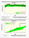
It was very hot for the first week of the month and then it was just a bit hot for the rest. Overall it was a full 2 degrees above average and about 4 degrees hotter than what we saw last year in July.
The high temperature of 33.1 °C on the 5th was the warmest day since August 1st of 2007 and the 5 days in a row of temperatures over 30 (from the fourth to the eighth) was the first time that happened since 2005. On the night of the 5th (morning of 6th) the temperature only got down to 21.9 °C making it the warmest night since August 1st of 2006.
It was looking like a very average month for precipitation up until the morning of the 23rd, when we received over 35 mm between 7:45 am and 8:15 am. This was a 1 in 10 year precipitation event that caused some flooding in the area. At 65.2 mm it was also the wettest single day since July 11, 2008. (see some pictures of Silver Lake after the storm here: http://uwweatherstation.blogspot.com/2010/07/friday-mornings-significant-rain-event.html )
The total precipitation of 129.2 mm was definitely way above the average of 92.9 mm for the month, but not close to the record of 223.2 mm in 1988.
These last two very wet months have made up for the dry beginning to the year and we have now had the average precipitation for the first half of 2010.
Summary for July 2010:
Maximum Temperature 33.1 °C
Minimum Temperature 7.2 °C
Average Daily High Temperature 27.4 °C (Long term average 26.0 °C)
Average Daily Low Temperature 16.3 °C (Long term average 13.8 °C)
Total Precipitation 129.2 mm (Long term average 92.9 mm)
(Long term averages based on 1971-2000 data for the Waterloo Wellington Airport)
Sign up to get the monthly weather station summary by e-mail


9 comments:
I'm curious whether you've tried to assess whether there are any statistically significant differences between UW's temperature readings and the airport's (seeing as the normals you use are from the airport). As I noted a few posts back, every time I compare UW with the airport, UW has a higher dewpoint. (I've checked maybe 10 times since then, and this has held true, usually by more than a degree.) So I wonder whether there are differences in temperature readings as well (though if there are, they don't seem to be consistent or big enough to stand out like the dewpoint difference). A quick glance reveals that the low extremes at UW were much lower than at the airport for a couple of months last winter, but the averages appear close (again, at a quick glance).
The UW Weather Station has to use a 30-year block of data for trend comparison. Since the UW Weather Station doesn't have 30 years of its own data to use, it has to use the Waterloo Regional Airport weather station data for statistical comparison. I don't think it's the ideal situation, but it's all they've got, for now. The two weather stations are <15 km apart so they should be able to consider them within the same measuring graticule. (Typical meteorological data acquisition occurs in graticules of 20-25 km square.)
The temperatures are usually close but the humidity readings are often different (55 and 73.4 right now). The dew point is a calculated value, from the temperature and humidity. Is it possible that the proximity to Columbia Lake affects the humidity value? How is the humidity meter calibrated?
You have it mixed up. Dew point is measured, relative humidity is calculated (hence the "relative" part). Regardless, I'm not sure if the proximity to the lake affects it, but it's something I was wondering, too.
It is true that our humidity measurements are consistently higher than at the airport (and thus the dew point and humidex). As one person noted this may because of our proximity to Columbia Lake. When I have the time I'll look at some winter measurements (when Columbia Lake is frozen over and hence not evaporating any water) and see if the difference still exists.
About the temperature, the last time I compared ours to the airport we were within 0.04 degrees on average (or something like that, I don't have the numbers in front of me).
But yes the different locations of the stations: UW weather station by a lake, EC beside two airport runways, can cause differences in the extreme high and low temperatures each one measures in any particular hour.
Thanks, Frank. I had wondered about evaporation from Columbia Lake. I don't know whether this is a relevant data point or not, but the dewpoint reading is usually actually higher at Toronto Pearson than at Toronto Island. E.g., in the last 25 hourly dewpoint readings, Pearson was higher for 14, the island for 2, and they were even for 9. Maybe that's due to there being less heat at the island to force evaporation; I dunno! To clarify, I certainly don't "blame" you for using the airport's historical data to peg normals; I was just wondering whether there might be some statistical bias.
from the Station Information page:
"Thus we are going to stick with calculating dew point temperature using temperature and humidity. We will use the official Environment Canada computation of dew point temperature..."
I've compared the numbers from the UW and airport archives for 2009. For every month, the airport's average high is higher than UW's. On the other hand, for 10 out of 12 months, the airport's average low is lower than UW's. The two months where the airport had a higher average low (by 0.1 in each case) were January and December. The average lows are higher at UW by more than a degree every month from May to September. (The greatest difference in average highs is 0.9 in September.) Not trying to make a case for anything in particular here; just satisfying my curiosity. But the higher average lows at UW lead me to wonder at least whether the fact that UW's average lows generally run higher relative to normal that its average highs do is a measuring artifact rather than an indication of a real temperature phenomenon.
The airport (YKF) is in a flat area and I believe the soils there may be on the sandy side being close to the Grand River flood plain. YKF is subject to radiational cooling on calm nights, and often is one of the cooler places in the mornings compared to neighbouring weather stations (Elora, Guelph, Hamilton, London). This effect happens in all seasons - all we need is clear skies, no wind and lots of time for radiational cooling to do its job.
Post a Comment