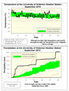
Overall the temperature was a degree above average, but this might not tell the whole story as the daily highs were exactly average while the daily lows were a full 2 degrees warmer than average.
However, it still may have seemed like a cool month as in the past decade September has been the month that has been most consistently above average. We have only had one September in the past 10 years that was colder than the 1971-2000 average (and that was only by 0.1 of a degree). So even though it was full degree above average this year, it was still the third coldest September of the past decade.
It turned out to be quite a wet month, in fact at 154.0 mm it was the wettest month we have seen in the area since September of 1996 (to be clear it was the wettest of any month of the year not just September).
What really got the month up there were 3 days with more than 30 mm of rain: 32.3 mm on the 3rd, 29.9 mm on the 16th, and 37.2 mm on the 38th. Ok the rain on the 16th wasn’t exactly 30 mm, but pretty close.
For the first time this year we have had more than the average amount of precipitation, 691.8 mm compared to 680.7 mm.
Summary for September 2010:
Maximum Temperature 30.6 °C
Minimum Temperature 4.0 °C
Average Daily High Temperature 20.0 °C (Long term average 20.0 °C)
Average Daily Low Temperature 10.3 °C (Long term average 8.3 °C)
Total Precipitation 154.0 mm (Long term average 87.5 mm)
(Long term averages based on 1971-2000 data for the Waterloo Wellington Airport)
Sign up to get the monthly weather station summary by e-mail


No comments:
Post a Comment