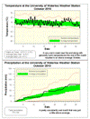
There was a warm stretch at the beginning of the month and one at the end, but no prolonged cold streaks. Thus the overall temperature for October was 1.4 degrees higher than average.
This continues the streak of above average temperatures for each month of the year. However, I compared this year to 1998 (which was the hottest year in the region) and even if the last two months were both 6 degrees above average it still wouldn’t be enough to be warmer than it was in 1998. Note that in the last 10 years, only one time has a month been 6 degrees above average, so I don’t see it happening twice in a row.
We also saw the first frost of the season on the 13th at 3:30 am, this was the first below zero reading since May 11th. The 155 frost-free days this year was about the average for the past decade.
The precipitation was on the high end of average for most of the month, but a few storms in the last week put us just above the average range.
A couple of wet months in a row means that we are now at 770.1 mm of precipitation for the year, a little above the average for this time of year which is 748.3 mm.
Summary for October 2010:
Maximum Temperature 22.5 °C
Minimum Temperature -2.3 °C
Average Daily High Temperature 14.4 °C (Long term average 13.2 °C)
Average Daily Low Temperature 4.4 °C (Long term average 2.9 °C)
Total Precipitation 78.3 mm (Long term average 67.1 mm)
(Long term averages based on 1971-2000 data for the Waterloo Wellington Airport)
Sign up to get the monthly weather station summary by e-mail


No comments:
Post a Comment