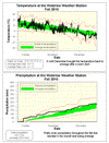
Up until the beginning of December it was looking to be a very warm fall. But since the start of the last month there have been only a few days that were above average. This brought the overall temperature for the fall down to half a degree above average, which is within the average range.
The precipitation was relatively well spread out over the season with the only prolonged dry spell occurring between late October and mid-November. The total precipitation was 228.7 mm which is a little higher than the average of 220.9 mm, but still within the average range.
For the second year in a row the total snowfall for the season of 30 cm was below the average of 40 cm and quite a bit lower than 2008 when we had 96 cm.
Summary for Fall 2010:
Maximum Temperature 27.6 °C
Minimum Temperature -17.4 °C
Average Daily High Temperature 8.8 °C (Long term average 8.3 °C)
Average Daily Low Temperature -0.1 °C (Long term average -0.5 °C)
Total Precipitation 228.7 mm (Long term average 220.9 mm)
(Long term averages based on 1970-2000 data for the Waterloo Wellington Airport)
Sign up to get the monthly weather station summary by e-mail


2 comments:
Thank You. I especially enjoyed reading the Fall 2010 Snow Report part.
Great fall summary Frank! It's interesting, even though December was colder than average, we are still waiting to see our first below -20 C reading at night this season. Similar surface weather patterns 20-30 years ago would have likely resulted in at least a handful of -20 to -25 C overnight lows by now.
Post a Comment