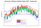
The year didn’t start out spectacularly warm with both January and February being just slightly above average. However March was the warmest since 2000 and the 6th warmest since records began and April was the warmest since 1955 and the 4th warmest in the region. Only 11 of the 61 days of those months were colder than average.
After a cold streak to start the month of May, it wasn’t until late October that there was another extended period of cold temperatures. But what was interesting was that that apart from a warm week early in July and one late in August the rest of the summer was consistently just a few degrees above average. November again was above average and it wasn’t until December that we had the only below average month of the year.
There were 11 days over 30 degrees during the year, higher than the average of 7 and much higher than the single day over 30 in 2009 and the 2 days in 2008. Even with the vast difference in the last 3 summers, the “end of summer” polls in all those years have resulted in a similar number of people that considered the summer to be great or good: 74% in 2010, 66% in 2009, and 77% in 2008.
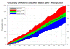
For precipitation, the year started off very dry with January being the driest since 1981 and fourth driest in the region since records began in 1914. The months that followed were also dry and by the end of May we only had about two thirds of the average precipitation. This was quickly offset by a very wet June (wettest in over 40 years) and July (wettest in over 15 years) that put us back into the average range.
August saw only a few days of rain, but before an extended drought could start September came in as the wettest single month since 1996 with three days having 30 or more mm of precipitation. Both October and November were average for precipitation while December only had about half of the average.
The final total was 879.3 mm which is close enough the average of 904.0 mm to say that for the second year in the row we had an average year of precipitation.
The most precipitation we saw on a single day was the 62.5 mm on July 23rd which was more than what fell during the entire months of January, February, March, August, or December. The 35 mm that we received that day between 7:45 am and 8:15 am was a 1 in 10 year precipitation event that caused some short term flooding in the area.
The 77.5 cm of snow we saw during the calendar year of 2010 was about half of the average of 159.5 cm. We didn’t get any measureable snow during March at the UW weather station and you have to back to 1946 to find another March like that.
Notable weather days of 2009:
January 27: The high temperature was only -4.1 °C breaking a streak of 14 days of above average temperatures.
March 26: The UW Weather Station blog predicts that the high temperature that day will be the lowest for at least the next 6 months. As it turns out it took until November 28th to see a colder day so it was actually over 8 months before a lower high was seen.
April 1: Thaigo Barolomei wins the UW Weather Station Contest with his guess of 1:00 pm.
May 3: Not really a weather event, but on this day at 5:15 am the UW Weather Station equipment experienced a major failure in the main logger unit. It would take until May 26th before the station was back in operation, resulting in by far the longest period of downtime for the station since operation began in February of 1998. We thank everybody for their patience during that difficult time.
July 5: The high temperature of 33.1 °C was the warmest temperature of the year and the highest since August 1, 2007. While the low temperature that evening was only 21.9°C, the warmest night since August 1, 2006.
July 15: As a big storm came through the area, the temperature dropped 4.3 degrees between 8:15 and 8:30 pm, the largest 15 minute temperature drop of the year.
July 23: A 1 in 10 year event between 7:45 am and 8:15 am saw 35.4 mm of precipitation fall and the day’s total of 62.5 mm was the single wettest day since July 11, 2008.
August 23: The high temperature was 2.4 degrees below average, breaking a streak of 2 weeks of above average temperatures.
September 2: More rain fell during a 24 hour period between the 2nd and the 3rd (51.9 mm) then during the entire month of August (36.2 mm).
October 13: The temperature dipped below zero for the first time since May 11, resulting in 155 frost free days for 2010. This was very close to the average number frost free days in the region which is 154.
Click on the image below to see the temperature chart:
Click on the image below to see the precipitation chart:


1 comment:
Thank You, Frank, for the lengthy and thorough report for the year 2010. About half way through, there is a title, "Notable weather days of 2009." Don't you mean, 2010?
Post a Comment