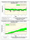
Although we didn’t see any extremely cold temperatures in December, it was colder than average for 25 days of the month, including a 20 day streak, while the only significantly warmer than average days came right at the end.
Overall it was 1.5 degrees lower than average, making it the only colder than average month the year and the coldest December since 2000.
With only 36.4 mm of precipitation it was a very dry month with just over half the average of 71.1 mm. This ties 1993 when we also had 36.4 mm and you have to go back to 1969 to a find a December with less.
Most of the precipitation came on the 12th with 15.3 mm in the form of wet snow and as far as total snowfall, we had 28 cm of the average 38.5 cm.
Summary for December 2010:
Maximum Temperature 8.5 °C
Minimum Temperature -17.4 °C
Average Daily High Temperature -2.6 °C (Long term average -0.4 °C)
Average Daily Low Temperature -8.3°C (Long term average -7.5 °C)
Total Precipitation 36.4 mm (Long term average 71.1 mm)
(Long term averages based on 1971-2000 data for the Waterloo Wellington Airport)
Sign up to get the monthly weather station summary by e-mail


2 comments:
Thank You for the Dec. 2010 report. We only got 28 cm of snow, compared with an average of 38.5 cm. So we got 72.7 percent of the average amount of snow, or about 10 cm (= 4 inches) less than average. Keep up the good work, Frank. Happy New Year.
I always wonder if the difference between the University of Waterloo and Waterloo airport temperature readings is as consistent as the difference between Kitchener vs. Waterloo stations for early 20th century (I believe you mentioned that Waterloo was consistently around 0.74 degree colder than Kitchener).
While the UW weather station recorded the coldest December since 2000, December '10 was actually warmer than December 05 according to the airport reading.
Post a Comment