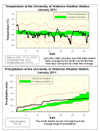
Unlike December, where we didn’t see any really cold temperatures, we had four days where it went below -20°C at night. This combined with many days that were a few degrees colder than average, put us as a little more than 2 degrees below average for the month. This was the first time since mid-2009 when we have had 2 below average months in a row.
On the 23rd, the high temperature during the day of -16.6°C was the coldest daytime high since January 15th of 2004 when it only got up to -17.8°C.
The month started out wet with lots of rain on the first, but it calmed down after that and the 54.8 mm of total precipitation was within the average range for the month.
The 42 cm of snow that came down during January was very close to the long term average of 43.5 cm. The largest single day was the 9.5 cm that fell during the 11th.
Summary for January 2011:
Maximum Temperature 10.1°C
Minimum Temperature -28.8 °C
Average Daily High Temperature -4.8 °C (Long term average -3.1 °C)
Average Daily Low Temperature -13.6°C (Long term average -11.1 °C)
Total Precipitation 54.8 mm (Long term average 64.4 mm)
(Long term averages based on 1971-2000 data for the Waterloo Wellington Airport)
Sign up to get the monthly weather station summary by e-mail


3 comments:
The last two months did indeed feel really cold, though for some reasons, it didn't feel like we're getting a lot of snow. I was surprised to find that we get about average snowfall for January, and only a little below for December...
Thank You.
I think for the past few years, the winters have had colder than average temperatures, and the rest of the year or the summers have had above average temperatures. I wonder if this trend will continue, or if winters will become increasingly colder and summers increasingly hotter. I'm starting to think the world's weather is becoming eccentric, but maybe off-balanced or teetering would be a better description. Like a children's triangle shaped plastic or metal toy top. When it is spun quickly, the top balances itself perfectly on the tiny point below, but as the top slows down it starts to look lop-sided in its revolutions, until it becomes so off-balanced it falls right over on its side and stops spinning. Is that the pattern our weather is going to take?
Post a Comment