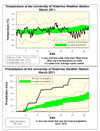
A cold March that was the wettest in almost 35 years
It was looking like an average month for temperature, but a very cold and clear last week put us 1.3 degrees below average. On some of these very cold days, the high temperature did not go above the average low temperature for the day.
The big story of the month was the 136.6 mm of total precipitation, this was almost twice the average of 70.6 mm and the wettest March since 1976 when we had 148.3 mm. There were two days with over 25 mm and three days in a row with over 15 mm. What
made it an even more astonishing total was that the last week of the month was dry.
With the biggest one day snowfall (26 cm) in three years happening on the 24th, it is not surprising that the month’s total snowfall of 50 cm was twice as much as the average of 24 cm.
This wet month put the amount of precipitation that we have seen for the year (254.8
mm), very much above average for the end of March (187.6 mm).
Summary for March 2011:
Maximum Temperature 13.6°C
Minimum Temperature -17.5°C
Average Daily High Temperature 2.4°C (Long term average 3.5°C)
Average Daily Low Temperature -7.1°C (Long term average -5.6°C)
Total Precipitation 136.6 mm (Long term average 70.6 mm)
(Long term averages based on 1971-2000 data for the Waterloo Wellington Airport)
Sign up to get the monthly weather station summary by e-mail


2 comments:
here's hoping that april is not a repeat of march as I am not looking forward to anymore freak blizzards (like today's)
It might be a bit risky, but should we call yesterday (with a high of 3.4 °C) the coldest daytime high for probably the next 6 months? Provided we can get through April without colder days of course...
Post a Comment