The wettest April ever recorded
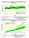
It may be surprising to some, but it worked out to be an average month for temperature. Overall it was actually 0.1 degrees above average, however as often happens the daytime highs were half a degree below average while the night time lows were about half a degree above. As people will naturally tend to notice the high temperature of the day, the feedback I got from people was that they were expecting it to be a colder than average month.
Although we had a stretch of 8 days where it didn’t go above 10°C, this was offset by a couple of warm days at the beginning of the month (including the 10th when the UW weather station contest was decided – congratulations to Janie Simpson on winning) and a few more warm days near the end.
Another thing that might have put people in a bad mood about the weather was the amount of precipitation. It turns out that the month of April was the wettest since records began in the area in 1914 with 136.5 mm coming down, this just barely beat 1921 when there was 135.9 mm.
Even more shocking is that on the 15th the total for the month was actually a bit below average at only 29.2 mm. But then storm after storm seemed to hit us with four days in the last half of April that recorded more than 15 mm, propelling us to the record breaking total.
Another wet month means that the amount of precipitation that we have seen for the year (391.4 mm) is very much above average for the end of April (264.4 mm). This is now the second wettest first 4 months of the year, just barely behind 1954 when we had 401.3 mm at this point.
The final total for the snowfall season of 2010/2011 was 177 cm compared to the average of 159.5 cm, it came down to the wire with the last real storm of the season on March 23/24 putting us above the average.
Summary for April 2011:
Maximum Temperature 22.3°C
Minimum Temperature -3.6°C
Average Daily High Temperature 10.9°C (Long term average 11.4°C)
Average Daily Low Temperature 1.3°C (Long term average 0.6°C)
Total Precipitation 136.5 mm (Long term average 76.9 mm)
(Long term averages based on 1971-2000 data for the Waterloo Wellington Airport)

Sign up to get the monthly weather station summary by e-mail


4 comments:
Certainly had more than our fair share of "April showers". I'm pretty sure I saw a man building an Ark!
Would it be possible for you to summarize "solar radiance" against Retscreen data or another recognized solar radiance historical data set or just provide the data sums. Lewis Nickerson
A combination of the mid month cold spell and memories of the very warm April 2010 likely combined to the perception that this April would have been expected to be colder than "average". We did at least have 4 days of 20 C or better, so there is hope!
Post a Comment