It is that time of year again, time to put in your guess as to when the temperature will first go above 20.
Get all the details and enter the contest here.
Thursday, February 24, 2011
Friday, February 18, 2011
Finally above zero
When the temperature when above zero on February 13th it broke a streak of 42 days of below zero temperatures.
Thursday, February 17, 2011
Warmest day since the new year
If the forecasted high of 8°C comes to pass today, it would be the warmest day since January 1st.
Friday, February 11, 2011
Last cold day for a while?
There is definitely a change coming, after Friday where the low dipped to -23.4°C in the morning, it looks like the temperature is going to slowly going to go up and up. It might not go down again till sometime on Sunday (maybe even Sunday evening).
And it's not just the short term that sees higher temperatures, with some forecasted highs of 6 in middle of next week.
After that, the medium range forecasts have it staying either at or a bit above average into mid-March. Thus I'll be bold and predict that today is going to be the coldest day we see until the fall.
Thursday, February 3, 2011
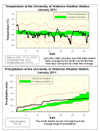
January 2011 Summary
The second colder than average month in a row with average precipitation
Unlike December, where we didn’t see any really cold temperatures, we had four days where it went below -20°C at night. This combined with many days that were a few degrees colder than average, put us as a little more than 2 degrees below average for the month. This was the first time since mid-2009 when we have had 2 below average months in a row.
On the 23rd, the high temperature during the day of -16.6°C was the coldest daytime high since January 15th of 2004 when it only got up to -17.8°C.
The month started out wet with lots of rain on the first, but it calmed down after that and the 54.8 mm of total precipitation was within the average range for the month.
The 42 cm of snow that came down during January was very close to the long term average of 43.5 cm. The largest single day was the 9.5 cm that fell during the 11th.
Summary for January 2011:
Maximum Temperature 10.1°C
Minimum Temperature -28.8 °C
Average Daily High Temperature -4.8 °C (Long term average -3.1 °C)
Average Daily Low Temperature -13.6°C (Long term average -11.1 °C)
Total Precipitation 54.8 mm (Long term average 64.4 mm)
(Long term averages based on 1971-2000 data for the Waterloo Wellington Airport)
Sign up to get the monthly weather station summary by e-mail
Groundhog Day storm final total
In the end we got 16.5 cm of snow at the UW weather station in total over the two days of the Groundhog Day storm. Not quite as much as forecasted as it seemed that most of the heavy snow went to the south hitting the Hamilton region.
As forecasted the storm also lost a lot of its power after hitting Chicago and didn't produce the snow amounts here as it did there.
As forecasted the storm also lost a lot of its power after hitting Chicago and didn't produce the snow amounts here as it did there.
Tuesday, February 1, 2011
Stories from the storm
I'm interested in hearing your stories about this storm, leave a comment with your experiences so far.
Groundhog Day storm of 2011
So once the snow starts on Tuesday night it doesn't look like it will stop until very late Wednesday or even Thursday. Although the heaviest part will probably be around sunrise, it now looks like we might get hit by a wrap around arm of the storm during the afternoon which might add another 10 cm to whatever already have at that point.
I'm interested in hearing about people's predictions and stories about the storm.
So on this post I encourage you to leave a comment saying how much total snow we will recieve between Tuesday night and Wednesday evening, ie. what will be the sum of the readings from Wednesday and Thursday morning at the UW weather station website.
I'll have another post where you can post any stories about the storm.
Subscribe to:
Posts (Atom)


