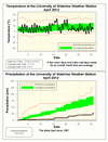
It was something that had never happened in the recorded weather history of our area: it was actually colder in April than it was in March. However, April was still not colder than average, this speaks to just how incredibly warm it was during March.
There was a bit of hot streak in the middle of the month, but this was offset by a cooler end of the month. Overall, the temperature was 0.1 degree higher than average, thus it was certainly within the average range.
Once again it was very dry this month, only 28.9 mm compared to an average of 76.9 mm. This makes it the driest April since 1977 when we only got 25.5 mm.Of course this means we are even further behind for the annual total which stands at 179.9 mm compared to the average of 264.4 at this point in the year
.
Summary for April 2012:
Maximum Temperature 22.9°C
Minimum Temperature -4.6°C
Average Daily High Temperature 11.7°C (Long term average 11.2°C)
Average Daily Low Temperature 0.2°C (Long term average 0.4°C)
Total Precipitation 28.9 mm (Long term average76.9 mm)
(Long term averages based on 1971-2000 data for the Waterloo Wellington Airport)


No comments:
Post a Comment