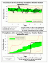
Apart from one ridiculously hot day, it was just warm the rest of the month, but this was enough to make it one degree above average overall. More on that ridiculously hot day: On September 10th the temperature got up to 34.7°C, this was the warmest day since July 21, 2011 (36.7°C), the hottest September day since 1953 (36.7°C), and the 4th hottest September day ever in the region since records began back in 1915.
I don’t know if there has been a month like this one for precipitation, 94.1 mm of the total of 97.9 mm came during a single 24 hour period. Since we don’t have hourly precipitation data going back past the start of the UW weather station it is hard to tell how it ranks. Based on 2 day totals the last time we might have had this wet a 24 hour period was on July 14-15, 1985 and then maybe again back in 1968, 1954, 1927, and 1915. By the way, the average for the month is 87.5 mm.
We have moved up in the year to date precipitation rankings and we are back up to the second wettest first 9 months of the year behind only 1940. The numbers are 903.3 mm so far compared to the average of 685.5 mm.
PS A few words about the summer of 2013, it was a degree above average and much wetter (390.7 mm) than average (274.0 mm), but we only have to go back to 2008 to find a wetter one (416.2 mm).
Summary for September 2013:
Maximum Temperature 34.7°C
Minimum Temperature 1.6°C
Average Daily High Temperature 21.0°C (Long term average 20.0°C)
Average Daily Low Temperature 9.3°C (Long term average 8.3°C)
Total Precipitation 97.9 mm (Long term average 87.5 mm)
(Long term averages based on 1971-2000 data for the Waterloo Wellington Airport)


No comments:
Post a Comment