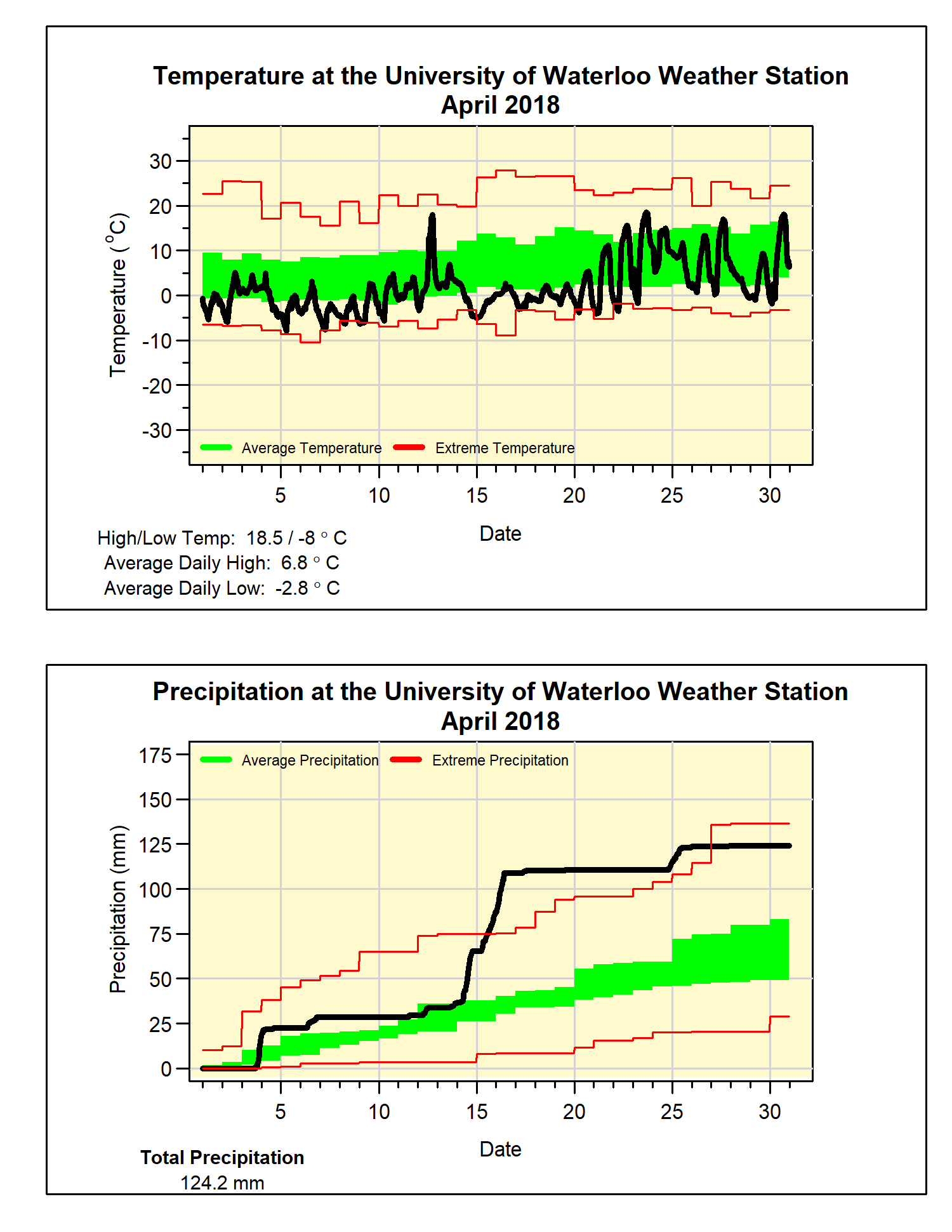
A wet April that was the coldest on record
Yes it was cold in April, but not just kind of cold, record
breaking cold! At 4 degrees below
average, it was the coldest April we have seen in the region since records
began back in 1915 beating the previous record set back in 1975. It was also the most below average month
since February of 2015.
It was cold right out of the gate as 20 of the first 21 days
of the month were less than average and there were only a total of 6 days overall
that were warmer than average.
During 3 really wet days between the 14th and the
16th there was a total of 72.6 mm of precipitation, this was almost
more than monthly average total of 74.5 mm.
Not surprising the final total of 124.2 mm was well above average.
Let’s call an end to the snow season (I know famous last
words), so the 10 cm we had in April puts the total for the snowfall season of
110.5 cm which is only about two thirds of the average of 159.7 cm.
Summary for April 2018:
Maximum Temperature 18.5°C
Minimum Temperature -8.0°C
Average Daily High Temperature 6.8°C (Long term average 11.5°C)
Average Daily Low Temperature -2.8°C (Long term average 0.8°C)
Total Precipitation 124.2 mm (Long term average 74.5 mm)
(Long term averages based on 1981-2010 data for the Waterloo-Wellington Airport)


5 comments:
It is SO nice to finally be able to get back on the bike, after the fake spring and second winter :-/
Bad timing for the weather station to go down during Hurricane force wind gusts on May 4th. 120 km/h gusts would have been close to record breaking.
It was the worst April. It would've been neat if the station malfunctioned right before May 1 however it was never in doubt whether the first 20ºC reading would occur that particular day or between the two entries (10 am is extremely early).
Very cold Aprils tend to be followed by warmer than average Mays, as we sort of "flip" right into summer mode. That was the case this year. It will be interesting to see May's numbers. At the Waterloo Airport Station, May's mean temperature of 16.0 was the warmest since May 1998 when a mean of 16.1 C was recorded. However, the average daily maximum temperature of 23.4 C for this May is the highest on record for the WAterloo Airport Weather station (records there go back to 1970).
The May summary just came out and confirms it being the warmest May since records began. 5ºC higher than normal for the daily high! Like many parts of the central Plains and mid-west, this is the largest swing in monthly averages ever recorded. I was hoping for a repeat of May 1975...it mostly delivered!
Post a Comment