Monday, December 13, 2010
Sunday, December 5, 2010
November 2010 Summary
Again with the hot temperatures and average precipitation
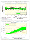
November kept the streak going for 2010 with an overall temperature that was a degree hotter than average. We have now seen above average temperatures for each of the 11 months of the year.
There was a regular hot streak from the 8th to the 14th and then a crazy 25 hours around the 22nd when it never went below 10 °C. On the graphs you can really see the difference in the daily cycle of temperature between the sunny/dry first half of the month and the cloudy/wet second half.
So after that incredibly dry first half of November, the second half made up for it getting us into the average range for the month. The total precipitation for the month was 72.7 mm with almost half of that coming on two wet days (16.8 on the 16th and 17.4 on the 30th).
We are now at 842.9 mm of precipitation for the year, a little above the average for this time which is 830.3 mm. It also looks likely that for the second year in row we will have an overall average year for precipitation.
Summary for November 2010:
Maximum Temperature 16.3 °C
Minimum Temperature -8.9 °C
Average Daily High Temperature 8.3 °C (Long term average 5.9 °C)
Average Daily Low Temperature -1.9 °C (Long term average -1.6 °C)
Total Precipitation 72.7 mm (Long term average 82.3 mm)
(Long term averages based on 1971-2000 data for the Waterloo Wellington Airport)
Sign up to get the monthly weather station summary by e-mail
Tuesday, November 23, 2010
Cooling down today
As sometimes happens, the high temperature for Today occurred just after midnight and it is going to cool down rapidly during the day.
A great way to see just how fast the temperature is dropping is to look at the weather graphs: http://weather.uwaterloo.ca/UWweather_graphs.html
You can also see just how much higher the recent temperatures have been than the average high and low temperatures for this time of year, shown as green horizontal lines on the graph.
Thursday, November 11, 2010
Opinions on the clock change
Now that we have had time to adjust to standard time I have heard and read a lot of opinions on whether or not people like it when the clocks change.
There are of course only so many hours of daylight and that number is going down these days. When we go to Daylight Saving Time in the spring we shift an hour of daylight into the evening.
Thus at this time of year, the clock change takes an hour from the evening and puts it back to the morning (we are now on standard time).
To find out what people think, I have put a poll on the UW weather station blog asking whether people would rather have that extra hour in the evening or the morning or are just indifferent.
As well as voting you can leave a reply to this post giving your reasons.
Thursday, November 4, 2010
October 2010 Summary
Another hot month with above average precipitation
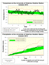
There was a warm stretch at the beginning of the month and one at the end, but no prolonged cold streaks. Thus the overall temperature for October was 1.4 degrees higher than average.
This continues the streak of above average temperatures for each month of the year. However, I compared this year to 1998 (which was the hottest year in the region) and even if the last two months were both 6 degrees above average it still wouldn’t be enough to be warmer than it was in 1998. Note that in the last 10 years, only one time has a month been 6 degrees above average, so I don’t see it happening twice in a row.
We also saw the first frost of the season on the 13th at 3:30 am, this was the first below zero reading since May 11th. The 155 frost-free days this year was about the average for the past decade.
The precipitation was on the high end of average for most of the month, but a few storms in the last week put us just above the average range.
A couple of wet months in a row means that we are now at 770.1 mm of precipitation for the year, a little above the average for this time of year which is 748.3 mm.
Summary for October 2010:
Maximum Temperature 22.5 °C
Minimum Temperature -2.3 °C
Average Daily High Temperature 14.4 °C (Long term average 13.2 °C)
Average Daily Low Temperature 4.4 °C (Long term average 2.9 °C)
Total Precipitation 78.3 mm (Long term average 67.1 mm)
(Long term averages based on 1971-2000 data for the Waterloo Wellington Airport)
Sign up to get the monthly weather station summary by e-mail
Subscribe to:
Comments (Atom)


