Tuesday, March 6, 2012

February 2012 summary

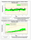
The second warmest February on record with just barely average precipitation

Sorry to keep repeating myself, but yet another very warm month that was 4.5 degrees higher than average.  This makes it the second warmest February since records began in the area almost 100 years ago, and just a few tenths of a degree cooler than 1998 which was the warmest.  This is now the 11th month in a row with above average temperatures.

It was the second warmest meteorological winter (Dec-Jan-Feb) just beating 2001-2002, but a full degree off of the record which was back in 1931-32.  We will see how it stacks up against other astronomical winters in a few weeks.

It was the first month since August that we had less than average precipitation, but with 2.7 mm on the leap day of February 29th it put the month just barely into the average range.

Even with the warm weather the amount of snow that fell during the month (25 cm) was not that far below average (30.6 cm).  The total for the snowfall season has been 76 cm which is a little less than half of the average total of 160 cm.

Summary for February 2012:
Maximum Temperature 7.8°C
Minimum Temperature -14.6°C
Average Daily High Temperature 1.4°C (Long term average –2.0°C)
Average Daily Low Temperature -5.2°C (Long term average -10.7°C)
Total Precipitation 34.4 mm (Long term average 51.3 mm)

(Long term averages based on 1971-2000 data for the Waterloo Wellington Airport)


Monday, March 5, 2012

Website is having problems

I can't put this on the homepage so I'll put it here.  There are some internet problems with the University and as a result the weather station homepage is stuck at 2 am Sunday morning if you can connect to it at all.

Hopefully it will be resolved soon, but it is out of my hands.

Saturday, March 3, 2012

Windiest day in 10 years

At 2:30 am on the morning of March 3rd the wind speed peaked at an 42 km/h (note that this is not the highest wind gust, but rather the average wind speed over the 15 minute measurement period).

This is the highest average wind speed since March 9th, 2002.  OK actually not quite 10 years but close enough.

Looking at historical records I found it interesting that although the windiest average month is January, a lot of the extreme wind records actually occur during the month of March.  This includes the highest wind gust at the Waterloo Wellington airport of 120 km/h on March 30, 1981.

Friday, February 24, 2012

The 2012 weather station contest has started!

The entry period for this year's UW weather station contest has now started.

Enter your guess for when the temperature will first go above 20 degrees.

All entries must be in by 2:00 pm on Friday, March 2nd.

Enter the contest here

Thursday, February 9, 2012

January 2012 Summary

January was another warm month with average precipitation

For the third month in a row it was a little over three and half degrees warmer than average with only a couple (OK maybe three) cold days. However, just like last month we only have to go back to 2006 to find a warmer January when it was over 6 degrees above average.

There was a total of 72.5 mm of all kinds of precipitation during the month, which is a bit above the average of 64.4 mm, but still within the average range. In fact looking at the graph (see link below) it shows that it was consistently within the green average zone for most of the month.

The total snowfall of 30 cm was much less than the 43.5 cm of the average January, but perhaps not as little as one might have expected with the much higher temperatures.

Summary for January 2012:
Maximum Temperature 8.2°C
Minimum Temperature -18.3°C
Average Daily High Temperature 0.2°C (Long term average –3.1°C)
Average Daily Low Temperature -6.9°C (Long term average -11.0°C)
Total Precipitation 72.5 mm (Long term average 64.4 mm)

(Long term averages based on 1971-2000 data for the Waterloo Wellington Airport)