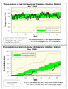
Nothing much to say about the temperature in May, it was pretty much average for the entire month. The final overall average temperature was half a degree below average, but this is not enough below the average to put it outside of the average range.
I really don't want to jinx it, but the last time the temperature was below zero was on the morning of May 18th (the Monday of the Victoria Day long weekend). Assuming this holds, it will be the second latest first frost day in the 11 year history of the UW weather station (back in 2002 the last frost day was May 21st).
Up until the 26th it looked like it was going to be a dry month, but in the last 5 days an impressive 42.2 mm came down pushing us up to 73.0 mm, just below the average of 75.7 mm.
As only January had below average precipitation, the first 5 months of 2009 collectively have come in as far above average. The total for the year is 409.4 mm compared to an average of 337.7 mm. Last year (which was the third highest total precipitation on record) at this time we only had 378.9 mm, but it was really the second half of 2008 that put us close to the record so we probably shouldn't read too much into it.
Environment Canada prediction of temperature for the month: Above average
Actual Temperature: Average
Summary for May 2009:
Maximum Temperature 26.3 °C
Minimum Temperature -0.8 °C
Average Daily High Temperature 18.1 °C (Long term average 18.9 °C)
Average Daily Low Temperature 6.2 °C (Long term average 6.6 °C)
Total Precipitation 73.0 mm (Long term average 75.7 mm)
(Long term averages based on 1971-2000 data for the Waterloo Wellington Airport)
Sign up to get the monthly weather station summary by e-mail


No comments:
Post a Comment