Between 2:15 and 2:30 yesterday afternoon, 6.6 mm of rain fell.
This is the highest 15 minute precipitation since last August 10th when we had 14.4 mm.
Tuesday, June 30, 2009
Wednesday, June 24, 2009
Hottest day since 2007
Wednesday's high of 31.3°C was the hottest temperature seen at the UW weather station since August 3rd, 2007, when it was 32.7°C.
Heat like we haven't seen for a while
Yesterday's high of 29.3°C was the highest we have seen since last September 3rd.
And if we do hit the predicted high of over 30 today it might be the hottest it has been in a couple of years.
But we are probably not going to go above the 32.7°C back on August 3rd, 2007.
And if we do hit the predicted high of over 30 today it might be the hottest it has been in a couple of years.
But we are probably not going to go above the 32.7°C back on August 3rd, 2007.
Monday, June 22, 2009
Wow an actual hot day
When the temperature went up to 25.2°C on Sunday, June 21st it was the first time that the temperature had been a full degree higher than average since May 24th.
Sunday, June 21, 2009
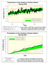
Spring 2009 Summary
A wet spring with average temperatures
It was a little warm at times and a little cool at times, but the temperature for the spring never really took hold one way or the other for any long stretches except near the end. The final numbers put the daytime highs about 0.6 degrees below average and the nighttime lows about 0.2 degrees below. This works out to 0.4 degrees less than average overall and that's close enough to zero to make the temperature average for the spring.
But for those who thought it seemed really cold this year, it was the coldest spring since 2003. Also, when you look at the graph of the recent temperatures you can see that it has been pretty steady since late May (the last time we had a daytime high that was more than a full degree above average was back on May 24th) and I think this has made people really wonder if the warmer temperature are ever going to arrive.
We had had a pretty consistent rate of precipitation for the spring as we were always hanging around the border between the average and above average range. In the end, the total precipitation for the season was 264.6 mm, which is just 0.2 mm above the average range and thus we can call it an above average spring for precipitation. This also made it the wettest spring since 2004.
There were no particularly large storms during the season (the highest daily precipitation was 29.4 mm, pretty good, but not spectacular) and no extremely long periods of dry conditions, just 11 dry days in April.
I was also reading over the summary from the past winter and I ended that one by pointing out that we usually get about 13 cm of snow during the spring, just to finish that thought, we ended up getting 10.5 cm, so pretty much an average spring for snowfall.
Summary for Spring 2009:
Maximum Temperature 26.3 °C
Minimum Temperature -8.5 °C
Average Daily High Temperature 15.2 °C (Long term average 15.9 °C)
Average Daily Low Temperature 4.2 °C (Long term average 4.4 °C)
Total Precipitation 264.6 mm (Long term average 219.5 mm)
(Long term averages based on 1970-2000 data for the Waterloo Wellington Airport)
Sign up to get the monthly weather station summary by e-mail
Wednesday, June 17, 2009
Microsoft Vista sidebar gadget
NOTE: The gadget has been tested by IT staff at UW and they have found it to work as advertised. They did not see any way that a game or virus could have been installed along with the gadget.
Here is a Microsoft Vista sidebar gadget sent in by Hao Zhang.
You can download the zip file containing the gadget here.
There is a readme file here, but all it says is to extract the files in the zip file to this directory:
As before I don't have a way to test it out myself so please leave comments on what you think of it and any suggestions to make it better.
Here is a Microsoft Vista sidebar gadget sent in by Hao Zhang.
You can download the zip file containing the gadget here.
There is a readme file here, but all it says is to extract the files in the zip file to this directory:
%USERPROFILE%\AppData\Local\Microsoft\Windows Sidebar\Gadgets
As before I don't have a way to test it out myself so please leave comments on what you think of it and any suggestions to make it better.
Friday, June 12, 2009
Talking about the cold start to June
I was on Dave-FM Friday morning talking about the cool start to June with Carlos and Gayle.
Follow this link to listen to conversation.
Follow this link to listen to conversation.
Wednesday, June 10, 2009
Yes, it has been colder than average
Follow this link to AccuWeather.com to see a good rundown of why we have been seeing cooler than average temperatures over the past week or so.
Tuesday, June 9, 2009
The model of consistency
The forecast highs for the next week all range between 20°C and 23°C.
And it is not like we have been seeing any large temperature swings in the past few weeks either, the temperature has been pretty consistently a few degrees below average since the end of May.
And it is not like we have been seeing any large temperature swings in the past few weeks either, the temperature has been pretty consistently a few degrees below average since the end of May.
Friday, June 5, 2009
Oh to be in the Yukon
The high temperature in Whitehorse was 28.8°C on Thursday.
This is higher than any temperature we have seen so far this year.
But I also acknowledge that there will be some people who will prefer the just slightly below temperatures we have been seeing lately.
This is higher than any temperature we have seen so far this year.
But I also acknowledge that there will be some people who will prefer the just slightly below temperatures we have been seeing lately.
Monday, June 1, 2009
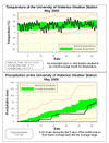
May 2009 Summary
An average month for both temperature and precipitation
Nothing much to say about the temperature in May, it was pretty much average for the entire month. The final overall average temperature was half a degree below average, but this is not enough below the average to put it outside of the average range.
I really don't want to jinx it, but the last time the temperature was below zero was on the morning of May 18th (the Monday of the Victoria Day long weekend). Assuming this holds, it will be the second latest first frost day in the 11 year history of the UW weather station (back in 2002 the last frost day was May 21st).
Up until the 26th it looked like it was going to be a dry month, but in the last 5 days an impressive 42.2 mm came down pushing us up to 73.0 mm, just below the average of 75.7 mm.
As only January had below average precipitation, the first 5 months of 2009 collectively have come in as far above average. The total for the year is 409.4 mm compared to an average of 337.7 mm. Last year (which was the third highest total precipitation on record) at this time we only had 378.9 mm, but it was really the second half of 2008 that put us close to the record so we probably shouldn't read too much into it.
Environment Canada prediction of temperature for the month: Above average
Actual Temperature: Average
Summary for May 2009:
Maximum Temperature 26.3 °C
Minimum Temperature -0.8 °C
Average Daily High Temperature 18.1 °C (Long term average 18.9 °C)
Average Daily Low Temperature 6.2 °C (Long term average 6.6 °C)
Total Precipitation 73.0 mm (Long term average 75.7 mm)
(Long term averages based on 1971-2000 data for the Waterloo Wellington Airport)
Sign up to get the monthly weather station summary by e-mail
Subscribe to:
Posts (Atom)


