However, take note that I never said that the lack of really warm temperatures was either good or bad, one thing I have learned over the years is that weather is very subjective and what one person considers a bad weather day is for someone else the most glorious day. Take for example this summer when even with the lack of hot weather, a poll on the weather station blog showed that 66% of people thought the weather was either good or great during the summer.
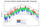
Looking at the graph for temperature there is a lot of green and not a lot of red or blue. Overall it was 0.06 degrees below average for the year which is close enough to put it into the average range. This makes it the coldest year since 2003 and only the second one that was even a little below the 1971-2000 average in the 11 complete years of record at the University of Waterloo weather station.
The year started off with a very cold January (the 6th coldest since records began back in 1915) but the rest of the winter and the early spring were warm. But then the middle of the year cooled off with July coming in as the 2nd coldest since 1915. It was interesting that the daily high temperatures for July were higher in Whitehorse than they were here.
After August it was generally pretty warm except for a couple of cold streaks in late August and mid-October. Only October came in a bit below average while November was the warmest since 2001 at almost 3 degrees above average. There was a stretch of 27 straight days starting in November with above average daytime highs.
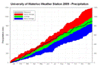
The first four months of the year were very wet, with April being the wettest since 1996 and the 5th wettest since records began. Although we weren’t exactly in drought conditions for the next 5 months, each one was a little below average. Thus when we hit the driest part of the year in September, a stretch of only 15.3 mm in 27 days, the total for the year was back in the average range. If the largest single day precipitation of the year had not come on the 28th September, it would have been close to a record dry month.
A wet October was then offset by a very dry November (the driest month of 2009) so that in the end, the final total precipitation of 899.1 mm was achingly close to the average of 904.0 mm. This comes after a very dry year in 2007 (671.9 mm) and a very wet year in 2008 (1159.5 mm).
Although the 2008-09 snowfall season was tied for the third highest of all time, after January’s impressive 62.5 cm the rest of that winter and the beginning of the 2009-2010 winter have been relatively snow free. Thus for the calendar year of 2009 the snow total is only 128 cm, much less than the average of 159.5 cm.
Notable weather days of 2009:
January 16: The last day of a really cold freeze where the temperature didn’t go above -10°C for over 3 days. On the 16th, with the high temperature of only -15.1°C, it was the lowest high temperature in almost 2 years.
April 7: Final snowfall of the season that had a total of 235.0 cm. This season tied with 1942-1943 as the third highest total of all time behind both the 245.3 cm in 1923-24 and the 257.5 cm in 2007-08.
April 24-25: After a chilly start to the day at 4.6°C the temperature went above 20°C by noon on the 24th and 23.6°C by the afternoon, it then started getting colder in the evening down to 13°C, but around midnight we saw the largest 15 minute temperature rise of the year of 4.2 degrees between 11:45 pm and midnight. It got warmer the next day with another high of 26°C, however between 3:45 and 4:45 pm the temperature dropped 10.1 degrees (a record at the UW weather station). I just thought it was interesting that the biggest temperature rise and drop happened on consecutive days.
July: It was the second coldest July since records in the area began in 1915. We only had 2 days during the month where the high temperature was above average, so that made for 29 below average days.
July 7: The high temperature only got up to 15.9°C. That was the lowest daytime July high temperature since 1997 and the fifth lowest since 1971.
August 17: The temperature only got down to 21.8°C, it was the warmest night since August 1st, 2006 when it only went down to 25.3°C.
September 28: The wettest single day of the year at 30.2 mm, although most of it (21.2 mm) came down between 6:45 and 8:15 am with the rest coming in a couple of smaller downpours in the afternoon.
October 11: Sometimes the first frost day just kind of skirts below zero for a few 15 minute readings. But this time the temperature stayed below zero for a good 11 hours starting on the night of the 11th.
December 4: It only got up to 0.3°C which was below average for the day. That broke a streak of 27 straight days of above average daytime highs.
Summary for 2009 (averages from 1971-2000 data for the Waterloo Wellington Airport):
Average Daily High Temperature: 11.67 °C (average 11.89 °C)
Average Daily Low Temperature: 1.80 °C (average 1.71 °C)
Total Precipitation: 899.1 mm (average 904.0 mm)
Extremes for 2009 (all time UW weather station extreme in brackets):
Highest Temperature:
31.3 °C June 24 5:30 pm (35.4°C Aug 8, 2001 4:30 pm)
Highest Humidex:
44.3 Aug 9 6:00 pm (46.8 Aug 2, 2006 3:45 pm)
Lowest Temperature:
-28.8 °C Jan 15 8:15 am (-32.3 °C Jan 27, 2005 7:45 am)
Lowest Windchill:
-29.9 Jan 17, 6:45 am (-37.2 Jan 14, 1999 4:15 am)
Greatest temperature drop in 15 minutes:
-4.9 °C Apr 25 4:30 pm (-5.7 °C June 8, 2007 4:00 pm)
Greatest temperature drop in 60 minutes:
-10.1 °C Apr 25 3:45-4:45 pm (New Extreme)
Greatest temperature rise in 15 minutes:
Tie – 4.2 °C Feb 5 9:30 am and Apr 24 11:45 pm (8.6°C Jan 2, 2001 6:15 am)
Greatest temperature rise in 60 minutes:
9.1 °C Feb 5 8:45 - 9:45 am (12.2°C Jan 2, 2001 4:45-5:45 am)
Highest Precipitation in 15 minutes:
15.4 mm July 11 9:00-9:15 am (23.0 mm July 22 7:30-7:45 pm)
Highest Precipitation in 60 minutes:
16.4 mm Sep 28 7:30 - 8:30 am (36.7 mm Jun 16, 1998 1:15-2:15 pm)
Highest Precipitation in 1 day:
30.2 mm Sep 28 (78.0 mm July 11)
Highest 15 minute average wind speed:
33.2 km/h Dec 9 8:15 pm (44.6 km/h March 9, 2002 6:30 pm)
Last time the temperature went below 0 before the summer:
May 18 3:30 am (Has ranged between Apr 29- May 21)
First time the temperature went below 0 after the summer:
Oct 11 9:45 pm (Has ranged between Oct 2-28)
Highest daily low temperature:
21.8 °C Aug 17 (25.3 °C Aug 1, 2006)
Lowest daily high temperature:
-15.1 °C Jan 16 (-16.1 °C Jan 9, 2004)
Largest daily temperature range:
20.4 °C Feb 7 (29.6 °C Feb 19, 2007)
Smallest daily temperature range:
2.4 °C Nov 20 (0.45 °C Dec 7, 2005)
Click on the image below to see the temperature chart:
Click on the image below to see the precipitation chart:


No comments:
Post a Comment