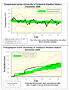
It was a very steady month for temperature with only 5 days that were either 5 degrees above or below average. With the daily high temperatures being 0.4 degrees below average and the daily low temperatures at 0.6 degrees above the overall temperature was 0.1 above average. However this is still within the average range.
Looking at the graph you can also see how little the temperature went up and down with the diurnal cycle (ie. daily), but went up and down over the course of a few days. This is reflective of the large numbers of overcast days during the month when the temperature is not affected by the sun but rather by large weather systems moving through the area.
Of the 79.6 mm of precipitation during the month, about 48 of them fell in the first 10 days which shows that the rest of the month was pretty dry. The average precipitation for the month is 71.1 mm so this month was at the top end but still within the average range.
We had a little over 30 cm of snow this month which wasl a bit below the average of 38.5 cm.
Summary for December 2009:
Maximum Temperature 9.2 C
Minimum Temperature -17.3 C
Average Daily High Temperature -0.7 C (Long term average -0.4 C)
Average Daily Low Temperature -6.9 C (Long term average -7.5 C)
Total Precipitation 79.6 mm (Long term average 71.1 mm)
(Long term averages based on 1971-2000 data for the Waterloo Wellington Airport)
Sign up to get the monthly weather station summary by e-mail


1 comment:
If I'm not mistaken, the December long term (1971 - 2000) averages for the Waterloo-Wellington airport are -0.2 °C and -7.3 °C. But I got that from Environment Canada, so the numbers might have been different from your source.
Post a Comment