There has been some talk about rainfall records being set in Toronto this summer.
I thought I should address this for Waterloo.
Here are the top 5 July precipitation totals:
1988 - 223.2 mm
1987 - 195.4 mm
1951 - 191.8 mm
1991 - 182.6 mm
1950 - 180.6 mm
Right now we are in 6th place for the July rainfall.
As of 10 am on July 28th we have had 164 mm.
We might be getting a few showers before the end of the month, but it is hard to imagine that we will get the 17 mm to catch up to 1950.
Here are the top 6 June/July precipitation totals:
1947 - 309.4 mm
1927 - 296.7 mm
1967 - 286.3 mm
1987 - 285.6 mm
1953 - 279.4 mm
1951 - 276.6 mm
Here we are only in 7th place with 270.4 mm.
However, we could move up depending on just how much we get this week as we only need 6 mm more.
Monday, July 28, 2008

Tuesday, July 22, 2008
Another week, another record rainfall.
On July 22nd between 7:30-7:45 pm 23.0 mm of rain fell.
That is the highest 15 minute rainfall we have recorded in the 10 year history of the UW weather station.
The previous record was 16.2 mm on June 27, 1999.
We also set an hourly record with 34.4 mm coming down between 7:15-8:15 pm.
That just surpassed the 33.9 mm on May 2, 2000.
By the way, I don't know how far back these records go, as they don't keep 15 minute data at the Waterloo-Wellington airport and I don't have their hourly data.
Not a record, but also interesting is that the temperature dropped 6.2°C between 7:15-7:45 pm.
On a personal note I happened to be biking just as the storm hit (I really should have checked the radar before I left) so I ended up watching the record rainfall from the (partial) shelter of one of the RIM buildings.
That is the highest 15 minute rainfall we have recorded in the 10 year history of the UW weather station.
The previous record was 16.2 mm on June 27, 1999.
We also set an hourly record with 34.4 mm coming down between 7:15-8:15 pm.
That just surpassed the 33.9 mm on May 2, 2000.
By the way, I don't know how far back these records go, as they don't keep 15 minute data at the Waterloo-Wellington airport and I don't have their hourly data.
Not a record, but also interesting is that the temperature dropped 6.2°C between 7:15-7:45 pm.
On a personal note I happened to be biking just as the storm hit (I really should have checked the radar before I left) so I ended up watching the record rainfall from the (partial) shelter of one of the RIM buildings.
Friday, July 18, 2008
A Warm Night
On the night between July 17th and the 18th the temperature only went down to 22.1°C making it the warmest night we have seen since August 1st, 2006.
That night (actually the night between July 31st and August 1st) in 2006 the temperature only went down to 25.3°C.
That night (actually the night between July 31st and August 1st) in 2006 the temperature only went down to 25.3°C.
Friday, July 11, 2008
Record Rainfall
On the morning of July 11th between 3 and 9 am we recorded 78.0 mm of precipitation at the University of Waterloo Weather Station. This is the highest one day total we have seen in the 10 year history of the weather station (beating the 59.2 mm on July 16th, 2005).
This is now the highest one day precipitation since July 7, 1991 when 82.0 mm was recorded at the Waterloo-Wellington Airport. The wettest day since 1970 was 89.8 mm on July 15, 1985.
The average monthly precipitation for July is only 92.9 mm and this morning we got more precipitation than we did in March, April, or May.
Looking at the GRCA gauges you can see that there was only a narrow path of really heavy precipitation with Laurel Creek getting 66.8 mm but Cambridge, Woolwich, and Conestogo only receiving around 27 mm. While Guelph only recorded 7.6 mm.
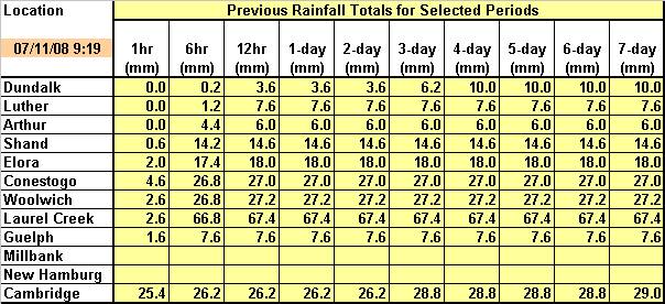
(if you can't read the numbers above, here is a clearer view)
As I biked by Silver Lake this morning the boardwalk was flooded and you could not see the weir structure at the end of the lake.
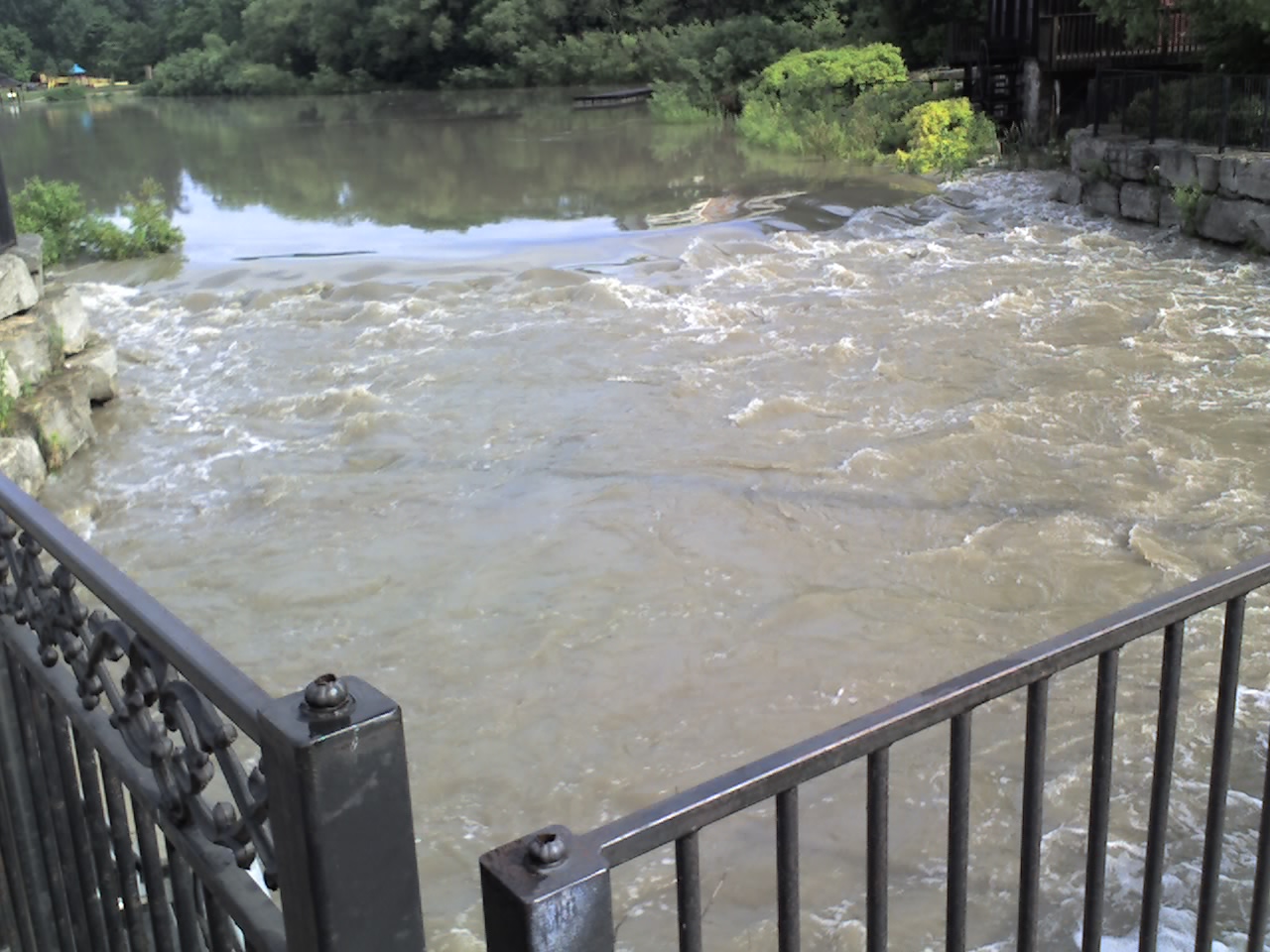
Silver Lake outlet at 12:30 pm, July 11th:
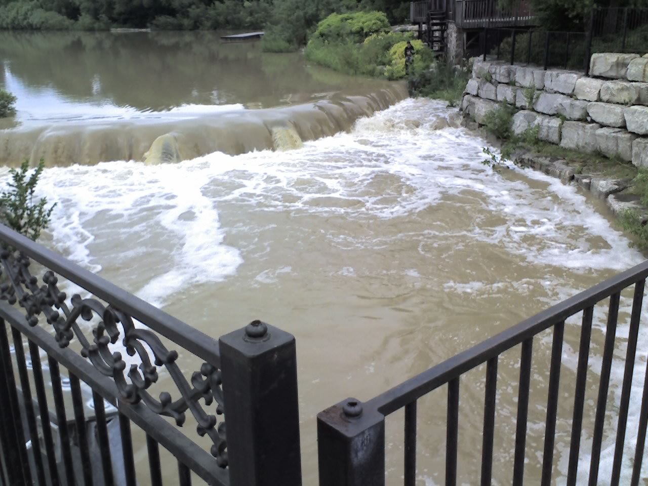 Silver Lake outlet at 9:00 am, July 14th (just to show what it usually looks like):

This is now the highest one day precipitation since July 7, 1991 when 82.0 mm was recorded at the Waterloo-Wellington Airport. The wettest day since 1970 was 89.8 mm on July 15, 1985.
The average monthly precipitation for July is only 92.9 mm and this morning we got more precipitation than we did in March, April, or May.
Looking at the GRCA gauges you can see that there was only a narrow path of really heavy precipitation with Laurel Creek getting 66.8 mm but Cambridge, Woolwich, and Conestogo only receiving around 27 mm. While Guelph only recorded 7.6 mm.
(if you can't read the numbers above, here is a clearer view)
As I biked by Silver Lake this morning the boardwalk was flooded and you could not see the weir structure at the end of the lake.
Silver Lake outlet at 9:30 am, July 11th:
Silver Lake outlet at 12:30 pm, July 11th:
Silver Lake outlet at 9:00 am, July 14th (just to show what it usually looks like):
Thursday, July 10, 2008
Divergent forecasts
It is hard to make plans for the weekend when the two major forecasts can't agree.
As of 10 am on Thursday the temperature predictions are similar for the weekend, but the probability of precipitation has some major differences:
POP values
Saturday
EC - 60%
WN - 20%
Sunday
EC - 60%
WN - 20%
Monday
EC - 40%
WN - 10%
EC=Environment Canada
WN=The Weather Network
As of 10 am on Thursday the temperature predictions are similar for the weekend, but the probability of precipitation has some major differences:
POP values
Saturday
EC - 60%
WN - 20%
Sunday
EC - 60%
WN - 20%
Monday
EC - 40%
WN - 10%
EC=Environment Canada
WN=The Weather Network
Subscribe to:
Posts (Atom)


 Posts
Posts

