We have a winner!
Well after our really cold winter, it wasn't the latest that the weather station contest ended.
Congratulations to Sarah Catherine Ptatschek
for only being 15 minutes off of the correct time of 5:00 pm
when the temperature first hit 20.0 C .
She also had an interesting reason for chosing this date:
13 is my lucky number and I think it was between May 13th or April 13th, the weather has been so weird I would normally go for May, but I am trying April this year!
and in second place we have H.T. Lam whose reason was a bit more direct:
No reason - just getting tired of the long winter
.
Let's do it again next year.
Sunday, April 13, 2014

Saturday, April 12, 2014
Could this be the end?
Could the weather station contest end tomorrow?
Latest forecast from EC has the high on Sunday going up to 20C.
Latest forecast from EC has the high on Sunday going up to 20C.
Saturday, April 5, 2014
March 2014 Summary
The second coldest and third driest March in the region
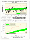
This was the second coldest March in the area since records began back in 1915, the coldest was back in 1960. Unlike February, this month we had a few breaks when the temperature went above zero, but of course most of the time it was well below average.
Overall, it was 5.6 degrees colder than average, this now makes it the most colder than average month in the history of the UW weather station, just surpassing last month. It is also quite the contrast to just 2 years ago when it was 7.6 degrees above average.
It was a very dry month with only 17.5 mm of precipitation, this means it was the 3rd driest March in the region. In a typical March we would get around 45 mm of rain and 24 cm of snow, this year we had 16.5 cm of snow and hardly any rain.
Summary for March 2014:
Maximum Temperature 10.9°C
Minimum Temperature -26.4°C
Average Daily High Temperature -1.0°C (Long term average 3.5°C)
Average Daily Low Temperature -12.4°C (Long term average -5.6°C)
Total Precipitation 17.5 mm (Long term average 70.6 mm)
(Long term averages based on 1971-2000 data for the Waterloo Wellington Airport)
This was the second coldest March in the area since records began back in 1915, the coldest was back in 1960. Unlike February, this month we had a few breaks when the temperature went above zero, but of course most of the time it was well below average.
Overall, it was 5.6 degrees colder than average, this now makes it the most colder than average month in the history of the UW weather station, just surpassing last month. It is also quite the contrast to just 2 years ago when it was 7.6 degrees above average.
It was a very dry month with only 17.5 mm of precipitation, this means it was the 3rd driest March in the region. In a typical March we would get around 45 mm of rain and 24 cm of snow, this year we had 16.5 cm of snow and hardly any rain.
Summary for March 2014:
Maximum Temperature 10.9°C
Minimum Temperature -26.4°C
Average Daily High Temperature -1.0°C (Long term average 3.5°C)
Average Daily Low Temperature -12.4°C (Long term average -5.6°C)
Total Precipitation 17.5 mm (Long term average 70.6 mm)
(Long term averages based on 1971-2000 data for the Waterloo Wellington Airport)
Sunday, March 23, 2014
Winter 2013/14 Summary
The coldest winter in 20 years, but (perhaps) surprisingly not that wet
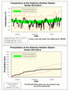
Very cold, that is all that really needs to be said about this winter. At 4 degrees below average it was the coldest winter we have seen in the region since 1993/94. What also made it feel colder was the fact that we didn’t see the typical thaws that we often get in January or February. This also meant that pretty much all the snow that fell since October was there in the snowbanks for the entire winter for all to look at every day.
In the media stories about this winter I have seen reports varying from the coldest winter in 20 years to the coldest in 38 years. It really depends on the station you are looking at as the 1993/94 winter was just a little colder than this past one so I think that is the reason for the variation in the records.
It was pretty wet during the first half of the winter, but then the second half was very dry. The total precipitation was 165.3 mm which is less than the average of 184.5 mm, but enough to be within the average range.
As it strange to talk about the snow just during the winter season, for the entire snowfall season we have had 164 cm compared to the average at this time of year of 148.5 cm. So above average but not really by that much.
Summary for Winter 2013/14:
Maximum Temperature 9.8°C
Minimum Temperature -31.2°C
Average Daily High Temperature -4.6°C (Long term average –1.4°C)
Average Daily Low Temperature -14.9°C (Long term average -9.8°C)
Total Precipitation 137.8 mm (Long term average 184.5 mm)
(Long term averages based on 1971-2000 data for the Waterloo Wellington Airport)
Very cold, that is all that really needs to be said about this winter. At 4 degrees below average it was the coldest winter we have seen in the region since 1993/94. What also made it feel colder was the fact that we didn’t see the typical thaws that we often get in January or February. This also meant that pretty much all the snow that fell since October was there in the snowbanks for the entire winter for all to look at every day.
In the media stories about this winter I have seen reports varying from the coldest winter in 20 years to the coldest in 38 years. It really depends on the station you are looking at as the 1993/94 winter was just a little colder than this past one so I think that is the reason for the variation in the records.
It was pretty wet during the first half of the winter, but then the second half was very dry. The total precipitation was 165.3 mm which is less than the average of 184.5 mm, but enough to be within the average range.
As it strange to talk about the snow just during the winter season, for the entire snowfall season we have had 164 cm compared to the average at this time of year of 148.5 cm. So above average but not really by that much.
Summary for Winter 2013/14:
Maximum Temperature 9.8°C
Minimum Temperature -31.2°C
Average Daily High Temperature -4.6°C (Long term average –1.4°C)
Average Daily Low Temperature -14.9°C (Long term average -9.8°C)
Total Precipitation 137.8 mm (Long term average 184.5 mm)
(Long term averages based on 1971-2000 data for the Waterloo Wellington Airport)
Sunday, March 2, 2014
February 2014 Summary
The coldest February since 1979 that was also dry
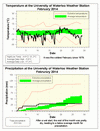
It was a very cold month, more than 5 degrees below average making it the coldest February since 1979. There was only a brief few days above 0 and the rest of the time it was not just a little cold but very cold. Overall it was the most below average of any month in the 16 year history of the UW weather station.
The low of -31.2 on February 12th was the coldest temperature since January 27th, 2005 when it was -32.2 and the second lowest February temperature I was able to find in the region (the coldest being all the way back in 1934).
The month started off a bit wet, but then it was pretty dry for the rest of the month putting the total of 30.6 mm below average overall. The 44.0 cm of snow in February was more than the 30.5 cm average. It may be surprising to know that the 147.5 cm of total snowfall really isn’t that much more than the average for this point in the season of 141.5 cm.
As we have now passed meteorological winter (the months of December, January, and February) the numbers for temperature show that it was the coldest met winter since 1977.
Summary for February 2014:
Maximum Temperature 4.4°C
Minimum Temperature -31.2°C
Average Daily High Temperature -5.9°C (Long term average -1.9°C)
Average Daily Low Temperature -17.2°C (Long term average -10.5°C)
Total Precipitation 30.6 mm (Long term average 52.6 mm)
(Long term averages based on 1971-2000 data for the Waterloo Wellington Airport)
It was a very cold month, more than 5 degrees below average making it the coldest February since 1979. There was only a brief few days above 0 and the rest of the time it was not just a little cold but very cold. Overall it was the most below average of any month in the 16 year history of the UW weather station.
The low of -31.2 on February 12th was the coldest temperature since January 27th, 2005 when it was -32.2 and the second lowest February temperature I was able to find in the region (the coldest being all the way back in 1934).
The month started off a bit wet, but then it was pretty dry for the rest of the month putting the total of 30.6 mm below average overall. The 44.0 cm of snow in February was more than the 30.5 cm average. It may be surprising to know that the 147.5 cm of total snowfall really isn’t that much more than the average for this point in the season of 141.5 cm.
As we have now passed meteorological winter (the months of December, January, and February) the numbers for temperature show that it was the coldest met winter since 1977.
Summary for February 2014:
Maximum Temperature 4.4°C
Minimum Temperature -31.2°C
Average Daily High Temperature -5.9°C (Long term average -1.9°C)
Average Daily Low Temperature -17.2°C (Long term average -10.5°C)
Total Precipitation 30.6 mm (Long term average 52.6 mm)
(Long term averages based on 1971-2000 data for the Waterloo Wellington Airport)
Subscribe to:
Posts (Atom)


 Posts
Posts

