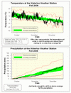
With 96 cm of snow, the fall of 2008 ranks as the third snowiest fall since records in the area began back in 1915 (the two snowiest were 1950 with 114.5 cm and 1951 with 105.5 cm). However what we got as snow we didn't get as rain, so the total precipitation of 250.4 mm puts it just barely above the average range.
Looking at the temperature, there were a couple of warmer than average periods during late September and early October. But after reaching 20 °C in early November the temperature was consistently lower than average for the rest of the season. Even though overall it was only 0.7 °C colder than the average, it still ranks as the coldest fall in the 10 year history of the UW weather station.
Summary for Fall 2008:
Maximum Temperature 26.2 °C
Minimum Temperature -18.8 °C
Average Daily High Temperature 7.9 °C (Long term average 8.5 °C)
Average Daily Low Temperature -1.1 °C (Long term average -0.3 °C)
Total Precipitation 250.4 mm (Long term average 222.5 mm)
(Long term averages based on 1971-2000 data for the Waterloo Wellington Airport)
Follow this link to see the graph showing the temperature and precipitation:
Sign up to get the monthly weather station summary by e-mail


2 comments:
Hi Frank - I measured 21 cm of snow in SE Kitchener as well. This was a heavy snowfall with what looks like a 9 to 1 snow to water ratio. Environment Canada will also have a storm summary statement out shortly on http://weather.ec.gc.ca
I find it interesting that despite being one of the snowiest falls on record, 2008 was also below average in terms of total rainfall.
Post a Comment