Friday, February 27, 2009
The big cool down has started
It is forecasted to go from the high of 8.3°C at 5:30 am this morning down to -10°C by 7 pm.
Be careful walking out there as all of those puddles are going to turn into ice sheets pretty fast.
Update:
The temperature went from a high of 8.3°C at 5:30 am to -7.4°C at 4:30 pm.
During the day there was a drop of about 15 degrees in 8 hours.
Be careful walking out there as all of those puddles are going to turn into ice sheets pretty fast.
Update:
The temperature went from a high of 8.3°C at 5:30 am to -7.4°C at 4:30 pm.
During the day there was a drop of about 15 degrees in 8 hours.
Thursday, February 19, 2009
The weather station contest has started
It is only appropriate to start the weather station contest on a cold, blustery day like today.
For those of you that don't know, to win the contest you have to guess the time and date that the weather station will first register a temperature of 20°C or greater.
The contest is free to enter (only one entry per person please) and there are prizes for the winners.
Get all the details on the contest entry page (link is below).
You have to put in your guess by 3 pm on Friday, February 27.
Good luck everybody!
Click here to go to the contest entry page.
Thursday, February 12, 2009
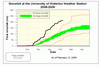
Snowfall summary - February 14, 2009
Haven't done this for a while, but here is the current snowfall summary for the season.
We are at 211 cm since the fall, this still puts us ahead of last year at this time (about 180 cm) but the gap is closing.
We will see in the next few weeks if we can set a new record.
Click on the image below to see the snowfall graph:
Quick update, look I'm not the only one to make snowfall graphs:
Minneapolis snowfall
That was a lot of rain
The total rainfall from Wednesday night to Thursday morning was 41.8 mm, breaking down to 25.1 mm on Wednesday and 16.7 mm on Thursday.
As the rain occurred over two days it is hard to tell exactly how many times we have had this much precipitation in February.
For instance we had 28.1 mm on February 4th, 2006, but only 10.1 mm the day before. So although the one day total was higher in 2006 there was more from this storm in total.
What I do know is that the highest one day February precipitation total was in 2001 on the 9th when we had 49.9 mm, not surprisingly it was also a rain event.
Looking back at the records going back to 1970 I wasn't able to find any other consecutive days with over 40 mm of precipitation. Thus I'm confident in saying that this was the second biggest storm we have seen in the area during February since 1970.
Monday, February 9, 2009
Revenge of the snow
Remember how you have been cursing the snow as you were shoveling it from your sidewalk over the last month? Well it's about to get its revenge.
With double digit temperatures forecasted in the next few days and up to 15 mm of rain, the world will look like quite a different place by the end of the week.
Although it got warm over this past weekend it wasn't enough to actually melt the snowpacks, it was just enough to make them angry (just like poking a wild animal).
The GRCA has issued a flood warning so everybody should keep away from streams and rivers the next few days.
As well if your basement is prone to flooding, this is probably a good time to look at it and make sure that everything that can't get wet is off the floor.
Saturday, February 7, 2009
First warm day in a while
The temperature on Saturday, February 7th got up to 6.1 °C making it the warmest day since December 28th of last year.
Thursday, February 5, 2009
Quick temperature rise
On Thursday the temperature rose from -20.7°C at 9:30 am up to -16.5°C at 9:45 am.
That isn't an all-time record 15 minute temperature rise, but might end up being the largest one for 2009.
And as we might be having the last really cold day of the season this seemed like a good time to put this in.
A recent comment on the blog asked:
Which is worse? A colder but drier freeze (Winnipeg) or a less cold, but more humid freeze (Southern Ontario)?
Leave your opinion in the comments below.
Sunday, February 1, 2009
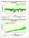
January 2009 summary
The coldest January in 15 years with lots of snow but no rain
Well that was a cold one, although January has 31 days like a lot of other months, it seems that this one just wouldn't end. The first part of January wasn't actually that cold, but one deep freeze between the 14th and 16th and another smaller one between the 24th and 26th put the overall temperature almost 4 degrees below average for the month.
The made it the coldest month (and of course the coldest January) since January of 1994 and the 6th coldest January since records in the area began back in 1915.
For the entire month we had a grand total of just over 3 hours where the temperature was above zero between 11:45 am and 3:00 pm on the 23rd. The low of -28.8 °C on the 15th was the lowest temperature we have seen at the UW weather station since January 28, 2005 when it was -30.5 °C.
Looking at the total precipitation we had 49.2 mm putting it below the average of 64.4 mm, but just enough to put it in the average range for precipitation. The snow total of 62.5 cm was above the average of 43.5 cm, however the reason we were low on the total precipitation is that we didn't have any rain where we would usually expect about 28 mm.
The total snowfall for the snowfall season (going back to the fall) is 202 cm, this puts us about 85 cm above where we were at this time last year and only 55.5 cm from the record total snowfall from last season.
Environment Canada prediction of temperature for the month: Average
Actual Temperature: Below average
Summary for January 2009:
Maximum Temperature 1.6 °C
Minimum Temperature -28.8 °C
Average Daily High Temperature -5.7 °C (Long term average -3.1 °C)
Average Daily Low Temperature -16.0 °C (Long term average -11.1 °C)
Total Precipitation 49.2 mm (Long term average 64.4 mm)
(Long term averages based on 1971-2000 data for the Waterloo Wellington Airport)
Sign up to get the monthly weather station summary by e-mail
Subscribe to:
Posts (Atom)


