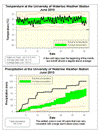
Apart from a 5 day cold stretch at the beginning of the month, the rest of June was pretty warm. Overall it was a full degree warmer than average, despite the fact that the highest temperature was only 28.3 °C, the lowest June high since 1993.
But the real story was the precipitation, at 130.3 mm it was the wettest June since 1967 and the wettest of any month since December 2008. The rain was consistent with a large storm (over 10 mm) occurring at least once a week and 17 days with some precipitation compared to 12 days on average.
But even with this really wet month the precipitation for the first half of the year is still a bit below average. We have had 372.3 mm so far in 2010 and the average at this point in the year is 415.0 mm.
Summary for June 2010:
Maximum Temperature 28.3 °C
Minimum Temperature 5.4 °C
Average Daily High Temperature 23.1 °C (Long term average 23.6 °C)
Average Daily Low Temperature 13.6 °C (Long term average 11.3 °C)
Total Precipitation 130.3 mm (Long term average 80.0 mm)
(Long term averages based on 1971-2000 data for the Waterloo Wellington Airport)
Sign up to get the monthly weather station summary by e-mail


2 comments:
Do you guys know if this trend will continue this month, or any warm and heavy rain will happen before August 10?
Post a Comment