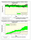
With an overall temperature over 2.5 degrees above average it was the hottest August since 1959. There was little relief from the heat as well, given that there were no days that were significantly (ie. more than 5 degrees) below average.
We still have not seen a month this year that has been below average, making this the warmest first 8 months of the year since 1998, which was the hottest year on record in the area.
It was a dry month with only 36.2 mm of precipitation when the average for August is 87.0 mm. Apart from a couple of days with around 10 mm, the rest of the month's precipitation were just a few sprinkles here and there.
Of course a dry month is going to also put us further behind for the year. So far we have had 534.2 mm in 2010, compared to the average of 596.0 mm at the end of August.
Summary for August 2010:
Maximum Temperature 33.1 °C
Minimum Temperature 7.5 °C
Average Daily High Temperature 26.8 °C (Long term average 24.7 °C)
Average Daily Low Temperature 15.9 °C (Long term average 12.6 °C)
Total Precipitation 36.2 mm (Long term average 87.0 mm)
(Long term averages based on 1971-2000 data for the Waterloo Wellington Airport)

Sign up to get the monthly weather station summary by e-mail


3 comments:
I suppose today (September 3) has more precipitation than the whole month of August
That is a good possibility..a direct hit from one strong and juicy thunderstorm can sometimes give a month's worth of rain in an hour or two. At the Waterloo International Airport station, 15.9of rain fell on Sept 03 .. which looks like only about half of what fell at the U of Waterloo station. I got 15 mm of rain from that at my house.
It's the nighttime lows that are scaring me a little. When I was growing up, the rule of thumb was that summer night temperatures were roughly half what they were during the day. This recent cool snap excepted, the lows this summer have been, usually, about two thirds of the daytime high. Sometimes even three quarters.
Post a Comment