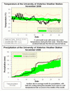
It isn’t very hard to see when the weather changed this November, after a few days that were close to 20 °C in the first week and a high of 8 °C on the 15th, the temperature went south and never again got above 2.5 °C. The contrast between the two halves of the month can clearly be seen in the temperature graph (see the link below); as well you can see the period near the end of the month when the temperature hovered around 0 for almost 4 days.
Overall the month was 0.8 degrees below average, this is a bit warmer than last year’s November when it was 0.9 degrees below average. However, the daily highs were actually colder this year than they were last year, but the daily lows were warmer making the overall average temperature a bit warmer.
Another month of above average precipitation with 115.0 mm coming down compared to the average of 82.3 mm. Most of this occurred between the 14th and 16th (48.8 mm), during the transition between the warm and cold parts of the month.
A total of 1023.2 mm of precipitation has been recorded so far this year, which is of course well above the average of 835.6 mm. We have now had the 3rd highest precipitation for the first 11 months of any year since records in the area began back in 1915.
It will however be difficult to end up with the wettest year on record, to do this we would need 163 mm in December to overtake 1985 and 151 mm to come in second just ahead of 1940. To put this into perspective the highest total precipitation for the month of December was 139.7 mm in 1949.
Summary for November 2008:
Maximum Temperature 20.4 °C
Minimum Temperature -12.8 °C
Average Daily High Temperature 5.2 °C (Long term average 6.1 °C)
Average Daily Low Temperature -2.0 °C (Long term average -1.4 °C)
Total Precipitation 115.0 mm (Long term average 82.3 mm)
(Long term averages based on 1971-2000 data for the Waterloo Wellington Airport)
Follow this link to see the graph showing the temperature and precipitation:
Sign up to get the monthly weather station summary by e-mail


3 comments:
Just curious Frank. Why are we no longer seeing the 15minute precipitation totals?
thanks
Re: the questions about the 15 minute precipitation totals.
When precipitation falls as rain we measure it using what is called a Tipping Bucket gauge, this gauge is very good at measuring small amounts of precipitation (down to 0.2 mm). When we are using this gauge, we put the 15 minute data on the website.
However, the Tipping Bucket cannot measure frozen precipitation, so when that type of precipitation is falling we measure it using a Weighing Bucket gauge (see the FAQ question: What does the precipitation reading mean during the winter? for a more in detailed description of this gauge).
Unfortunately, the readings from the Weighing Bucket gauges tend to "bounce" around a bit and they are not as responsive as the Tipping Bucket type so we only report the 1 hour and 24 hour accumulations.
Janak has a wide range of total station series for sale in Delhi/NCR, India like RTS700 series Total Station 810 Series, Total Station 680 Series, Total Station 650 Series.
Post a Comment