Wet, wet, wet. That was the weather story for 2008. I don’t think that will come as a surprise to most people if they think back to green lawns, lush gardens, and a whole lot of shoveling.
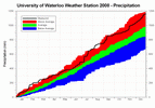
We finished with 1159.5 mm of precipitation in 2008 compared to an average of only 904.0 mm. This makes it the third highest annual total precipitation in the area since records began back in 1915. We were only 15 mm away from second place (1174.9 mm in 1940) and about 25 mm away from the all time record (1186.4 mm in 1985).
The abundance of precipitation was relatively consistent, with seven months of the year coming in with above average precipitation, 3 within the average range, and only 2 below average.
For the first half of the year the precipitation was merely above average, but then in July we saw 181.0 mm (the wettest month since July of 1991 as well as seeing a 1 in 25 year 6 hour storm and a 1 in 10 year 15 minute storm) and we started entering record territory. The precipitation didn’t let up for the rest of the year ending with the wettest December since 1949.
It was quite the contrast to the previous year, when the big weather story was how dry it was. In fact the amount we were over the average in 2008 was very close to the amount we were below in 2007, so if you take the total precipitation over the last 2 years it is very close to the average.
One final note about the precipitation, although I don’t normally like to talk about total snowfall in terms of calendar years, it is kind of interesting to break it up this way for 2008. The snowy winter and spring from earlier this year combined with the third snowiest fall to give us 326.5 cm for 2008. This is far and away the most for a calendar year, easily surpassing the old record of 257.4 cm back in 1924.
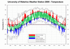
Looking at the temperature for 2008, we didn’t really see any extended periods of extremely above or below average temperatures. Overall it was 0.2 degrees above the 1971-2000 average; this still makes it the coolest year since 2004.
The year started off very warm, with January over 3 degrees warmer than average. Then more winter-like temperatures took hold and stayed until a brief warm spell in early April, but it wasn’t until late May that it really started to warm up. This combined with the record snowfall totals for the 2007-2008 snowfall season to make a lot of people think that winter would never end.
Although we didn’t see a single day above 30ºC during the summer, the average temperature for the season was higher than average. In a survey done on the UW weather station blog over 75% of people called it either a good or great summer, perhaps as a result of the lack of both smog warnings and extremely humid days.
These warm temperatures carried on into the early fall, however, the year ended with 3 consecutive colder than average months.
Notable weather days of 2008:
January 8: The high temperature on this day was 13.3°C, making it the 4th highest January temperature ever seen in the region.
February 27: Not really something to do with the actual weather, but this day was the 10th anniversary of the University of Waterloo weather station.
March 8 & 9: 31.5 cm of snow fell between the morning of the 8th and the 9th, this was the highest single day’s total since January 22, 1966.
April 4: The last 1 cm of snow was recorded, capping off the snow season of 2007-2008, which was the highest ever recorded in the region at 257.5 cm.
July 11: On the morning of July 11th between 3 and 9 am we recorded 78.0 mm of precipitation at the University of Waterloo Weather Station. It was the highest one day precipitation since July 7, 1991 when 82.0 mm was recorded at the Waterloo-Wellington Airport. So much rain fell that day you can see it clearly on the annual graph of precipitation.
July 22: On July 22nd between 7:30-7:45 pm 23.0 mm of rain fell. That was the highest 15 minute rainfall ever recorded at the UW weather station beating the previous record of 16.2 mm on June 27, 1999.
November 24-28: The temperature went above +1°C on the morning of November 28th, breaking a streak of 88 hours when the temperature stayed been between +1°C and -1°C. The longest previous streak of a 2 degree temperature range in the history of the UW weather station was back in 1998 between March 17th and 20th when we had 59 hours in that range.
December 27: The high temperature of 13.3°C was the highest December temperature since 2001.
Click on the image below to see the temperature chart:
Click on the image below to see the precipitation chart:


1 comment:
i enjoyed the summary of rediculous weather we've had this last year. i vaguely remembered it being weird, but sometimes years start blending together.
thanks for the detail. i enjoy reading the blog postings.
Post a Comment