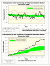
Except for a few notable warm days in the middle and near the end of the month, the rest of December was very cold. Overall it was full degree colder than average, making it the most below average month since May.
The high temperature of 13.3 °C on the 27th was the highest December temperature we have seen since 2001. This was the second of two “snow resets” we saw during the month, the other one occurred on the 15th when the temperature got up to 7.7 °C.
We almost set a record as the wettest December since records began in the area back in 1915. We had 136.3 mm of precipitation this year almost surpassing the 139.7 mm measured back in 1949. This was almost double the average for December of 71.1 mm.
There was also a lot of white stuff to shovel as we got 92 cm of snow, this is over twice the average of 38.5 cm and makes December 2008 the snowiest since 2000.
Environment Canada prediction of temperature for the month: Below average
Actual Temperature: Below average
Summary for December 2008:
Maximum Temperature 13.3 °C
Minimum Temperature -18.8 °C
Average Daily High Temperature -0.6 °C (Long term average -0.2 °C)
Average Daily Low Temperature -8.8 °C (Long term average -7.3 °C)
Total Precipitation 136.3 mm (Long term average 71.1 mm)
(Long term averages based on 1971-2000 data for the Waterloo Wellington Airport)
Follow this link to see the graph showing the temperature and precipitation:
Sign up to get the monthly weather station summary by e-mail


No comments:
Post a Comment