As a result, although we started out strong this season, we are now creeping towards last year's numbers.
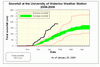
Looking at the snowfall graph you can see that last year (the top red line on the graph) was pretty much average until about mid-January and then it really took off to become the record breaking season it was.
It is by no means a certainty that we will surpass last year's total snowfall, even with the head start we had this year.
Click on the image below to see the snowfall graph:


8 comments:
I think the Favicon is pretty ugly...
In my defence it is my first flavicon.
Does it at least kind of look like the actual weather station structure.
OK, how about this, next week (after the January summary) we will have a "design the UW weather station flavicon" contest.
Perhaps your problem is you're making flavicons, when you're supposed to be making favicons? :)
I am wondering when did this extreme snowfall happened on the lower side? There were practically no snow until mid January!
To the anonymous comment:
I'm not really clear on what part of the graph you are commenting on.
Are you talking about this snowfall season or the last year's?
I was referring to the lower 'extreme' which is the lower red line on the graph.
M.
Sorry frank. I'm with Anonymous (1). I think the f(l)avicon looks a lot like the blair witch stick man. ;) Scary...
I think the favicon looks a lot like weather measuring instruments. I thought it was a nice touch the first time I saw it.
Post a Comment